Geospatial analysis is frequently used in urban planning. This project used geospatial analysis to assist with resource allocation in Austin, Texas. The city is opening another branch of the post office and needs to determine where the best location would be to better serve the people who are outside of the two-mile radius of the existing branches.
This map was created using ArcGIS Pro, a mapping and geospatial analysis software program. The data I used was gathered by Esri, a supplier of geographic information and the creator of ArcGIS Pro. My first step was adding a point layer for streets and post offices in Austin, so I can see the mapped locations of each point in both features. Next, I symbolized them so the post office locations are easily identifiable.
Afterwards I started working on the statistical analysis to determine how many of the streets are more than two miles from one of the post offices. I ran a query using SQL and the streets point layer. The query revealed there are 16,477 streets in Austin that are more than two miles from a post office. The image below shows only these streets and the post offices rather than the full layer of streets.
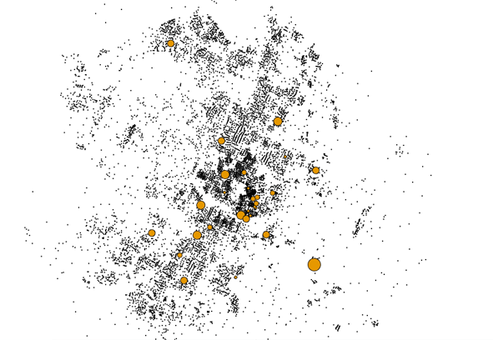
City planners can use this map to see clusters of streets outside the radius of post offices as part of the information they will use when determining the best location for the next post office.
